Foreshore and coastal creek projects

The information below is about current and upcoming projects and activities in foreshore and coastal creek areas. Please note these projects and activities sit outside the scope of the Eastern Beaches Foreshore Management Plan.

Project

Timing

Contact Officer/Mailbox/For further information

Beach access and associated community infrastructure design standards

April/May 2023

environment@noosa.qld.gov.au

Burgess Creek Bushland Reserve Ecological Restoration Plan

Complete

Natural Area Management

environment@noosa.qld.gov.au

Burgess Creek Integrated Catchment Management Plan

2023-2024, subject to budget.

mail@noosa.qld.gov.au

https://www.noosa.qld.gov.au/burgess-creek

Eastern Beaches Community Bushland Care

Commenced, on-going

Noosa Community Bushland Care

environment@noosa.qld.gov.au

Environmental communication design standards

2024-2025, subject to budget

environment@noosa.qld.gov.au

Integrated Coastal Management for Open Coasts

  • Coastal Hazards
  • Climate Change
  • Coastal Monitoring

Commenced, on-going


Coastal Hazards Adaptation Plan (CHAP)

Coastal Monitoring

climatechange@noosa.qld.gov.au

Integrated Water Quality Monitoring Program

Commenced, on-going

environment@noosa.qld.gov.au

Noosa Eastern Beaches Creeks - High Risk Erosion Prioritisation and Planning

2024-2025

mail@noosa.qld.gov.au


  • This project proposes reducing the impact of pedestrian access on dunes and facilitating the reestablishment, maintenance and protection of natural vegetation. This starts by ensuring that an appropriate level of infrastructure of an appropriate standard is available at a location that both protects the environment and serves the community.

    For more information environment@noosa.qld.gov.au.

  • In response to environmental and social values, community interest and active participation and an annual $20,000 contribution from Unity Water for bushland restoration, Noosa Council has developed the Burgess Creek Ecological Restoration Plan. It maps the condition and management issues of the bushland, identifies the environmental and social values of a bushland reserve, sets targets, and guides implementation for ecological restoration. The aim is to restore the structure, composition, function, and dynamics of regional ecosystems to the highest practicable extent.

    For more information: Natural Area Management   

  • An Integrated Catchment Management Plan (ICMP) for Burgess Creek will establish a framework for it’s sustainable management and facilitate investigation of the catchment

    The Burgess Creek ICMP will

    • Investigate current hydrology, stream flow behaviour, groundwater flows, 3rd party flows and bank stability
    • Collate the ecological values of Burgess Creek and how these are being impacted by point
    • Undertake water quality investigations to determine:
    • Impacts of point and diffuse sources water quality issues within Burgess Creek
    • Compliance with Department of Environment & Science water quality objectives
    • Impact of historical landfills, rapid infiltration basins and night soil disposal areas on groundwater
    • Compliance with the Recreational Health Guidelines

    The Burgess Creek Integrated Catchment Plan has been submitted as a new initiative for the 2024-2025 Noosa Council Budget and will be developed in 2024-2025, subject to budget.

    For more information mail@noosa.qld.gov.au

  • Community Bushland Care volunteers, in partnership with Noosa Council, have been undertaking ecosystem restoration and maintenance activities in the beaches and coastal creeks between Sunshine Beach and the South Peregian stretch since the late 1990s.

    There are 8 active Bushcare groups between Sunshine Beach and Peregian between them hold 18 working bees per month for ten months of the year (Feb to November). Since 2016 Bushcare volunteers have planted more than 11,200 trees, removed more than 1,248 cubic meters of invasive environmental weeds and gained $300,798 of grant funding mostly in the Eastern Beaches and associated coastal creeks. These works also play a vital role in strengthening native vegetation resilience in the dunal ecosystems which act as an effective natural line of defence against potential sea level rise.  

    For more information Noosa Community Bushland Care or environment@noosa.qld.gov.au.

  • Officers working in environmental fields across Council are working together to develop design standards for natural areas and environmental communication products. The design standards will be used in Council’s foreshore and bushland reserves and in or near other areas with environmental values such as rivers and wetlands. It includes signs, leaflets and information sheets and online information.

    The Noosa natural areas and environmental communications design standards will be finalised by July 2025, subject to budget. To be cost-effective and resource conscious, new signs and communication products will be rolled out gradually, where and when they would normally be replaced or newly installed.

    For more information environment@noosa.qld.gov.au.

  • Coastal monitoring programs under the Coastal Hazards Adaptation Plan include:

    • CoastSnap Citizen Science Site with UNSW/UniSC at Sunshine Beach Lookout
    • Burgess Creek Monitoring Project with UniSC
    • Nearshore Coral Reef Monitoring with Reef Check Australia
    • Coast4D Citizen Science Monitoring with UniSC

    Other ongoing implementation projects under the CHAP include:

    • COASTS Project with University of the Sunshine Coast/UQ/EOMAP
    • Living Foreshores Noosa Phase 1 – Designing for Resilience
      • Noosaville Foreshore Resilience Project
      • Designing Dynamic Dunescapes
      • Coastal Wetland Prioritisation Study with UQ
    • Regional Coastal Process Model with Sunshine Coast Council
    • Offshore Sand Supply Investigation

    For more information Climate Change Coastal Monitoring climatechange@noosa.qld.gov.au.

  • The Noosa and Mary Rivers are valuable natural, social and economic assets to the people of the regions and visitors alike. Maintaining habitat, aquatic biodiversity and water quality is therefore of high importance to the Noosa Council and the community.

    Integrated Water Quality Monitoring ProgramWater quality monitoring1

    Noosa Council is developing an integrated water quality monitoring program, designed to enhance the data management capabilities and management responses for water quality related matters across both the Noosa and Mary River catchments. The water quality program includes both internal stakeholders from Council, and external stakeholders from local natural resource management groups (Noosa Integrated Catchment Association (NICA), Noosa & District Landcare (Landcare) and the Mary River Catchment Coordinating Committee (MRCCC)).

    The program includes:

    • Development of sub-catchment report cards which will provide opportunity to better understand the condition of specific waterways, in addition to the Healthy Land & Water Report Card, and guide future management actions
    • Deployment of three trial telemetry monitoring stations for real time monitoring water quality data
    • A public dashboard which will provide the community access to water quality data
    • Event-based and point source monitoring including high rainfall events and stormwater monitoring to determine pollutants entering our waterways
    • Workshops between community groups, universities and Healthy Land & Water to determine agreed priorities for the catchments and objectives for the program

    Waterwatch Programs

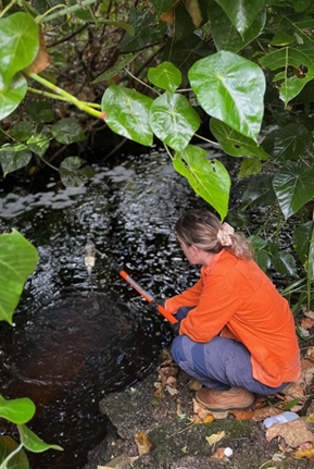
    Waterwatch Programs in the Noosa and Mary Rivers are run by community-based and integrated catchment organisations including the NICA, Landcare and MRCCC.

    NICA undertake water quality monitoring throughout the Noosa River at 30 sites on a monthly schedule, using a water quality probe to test parameters including pH, turbidity, dissolved oxygen and electrical conductivity.

    MRCCC undertake two biannual ‘Catchment Crawls’ in the Mary & Noosa Rivers, testing for in situ parameters including dissolved oxygen, turbidity, electrical conductivity and pH and laboratory analysis for nutrients, enterococci, e.coli and total suspended solids.

    Landcare conduct monthly water quality monitoring under the Keep it in Kin Kin project, which aims to protect the water quality and soil resources of the Noosa River system and the Kin Kin Catchment by reducing sediment movement through Kin Kin Creek.

    The Coastal Connect Bushland Care Waterwatch volunteers have been undertaking water quality sampling at Marcus Beach, Peregian Creek and Castaways Creek, including pH, turbidity, temperature, dissolved oxygen, conductivity and salinity are measured on a monthly schedule using a water quality meter. The baseline data is used to inform water quality at a sub-catchment spatial extent and to understand the impact of restorative works in the area.

    The data and observations from the groups are reported to Council and provide important information on the health of our waterways.

    The Waterwatch Programs are coordinated by local catchment and landcare groups with support through council’s grant programs. If you are interested in getting involved and supporting your local catchment. For more information on how to participate please contact:

    Noosa Council also undertakes monitoring at 4 locations in Burgess Creek to monitor the health of the catchment and is investigating expanding this program.

    Ecosystem Health Monitoring Program

    Since 2001, Noosa Council has been part of one of Australia’s most comprehensive freshwater, estuarine and marine monitoring programs delivered by Healthy Land & Water, the Ecosystem Health Monitoring Program (EHMP).

    The EHMP provides an annual health assessment of south-east Queensland’s major catchments, estuaries and Moreton Bay. It delivers a Report Card Rating for each catchment, based on the monitoring results.

    Over the last 18 years, the report card for Noosa River catchment has fluctuated between an A (excellent condition) and B (good condition) which is the best in the region.

    More information

    If you have an enquiry about waterways monitoring in the Noosa and Mary River catchments, please contact Council.

    Waterways and wetlands are a theme of council's Environment Strategy.

  • Since residential development, there have been issues with bank stability and sand slips along Eastern Beaches coastal creeks ranging from the minor movement of sand to drastic slip failure. Sand slips have the potential to impact public and private assets, and the natural assets that the Shire is known for. Presently Council is undertaking bank stability works in public land at two of the Eastern Beaches coastal creeks to protect private, public and natural assets.

    Traditionally Council has undertaken these works as a reactive action when sand slips happen, but this project proposed that Council adopts a process of assessing and prioritising works in the Eastern Beaches creeks to enable proactive management.  With this proactive approach, it is anticipated that potential slips stability issues will be identified early, reducing the cost of prevention, containment and rectification work, along with reducing social, environmental and water quality impacts.

    For more information mail@noosa.qld.gov.au