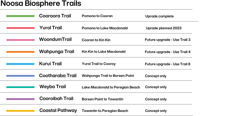
Noosa Biosphere Trails

Please be advised of the following maintenance works:
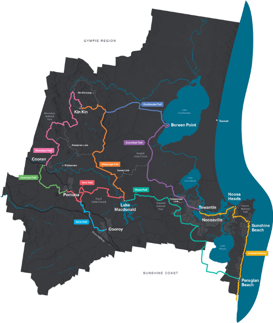
Woondum Trail - Upgrade works in Woondum National Park between Hill Rd and Upper Pinbarren Ck Rd have commenced. This trail section will be closed on weekdays until approximately April 2026.
Woondum and Wahpunga Trails - Upgrade works are progressing in stages along sections of Trail 3 (Woondum Trail) and Trail 4 (Wahpunga Trail), throughout January - March 2026. The works require temporary closures of short sections of trail to allow works to be completed safely. Please do not approach machinery and follow site signage and directions.
Users of Woondum Trail travelling towards Perserverance Road should proceed with caution as upgrade works are underway. Temporary detours may be in place.
Wahpunga Trail - Twin View Hills Lookout (formerly trail 2 & 4) is currently closed due to major repair work. This is the section from Cootharaba Road to Black Pinch Road. No alternative trail is available at this current time.
Thank you for your patience as we improve the Noosa Trail Network
The Noosa Biosphere Trails are located in the Noosa hinterland and are a popular destination for horse-riders, walkers, runners and bike riders.
The trails pass through forests, mountains and rural landscapes offering a diversity of experiences for users.
The Noosa Biosphere Trails are currently undergoing upgrades in line with the Noosa Trails Masterplan and the concept map available for download.
Development of the new trail maps and field guides are currently underway. In the meantime, trail users can refer to the old network map.
Download the Noosa Biosphere Trails map(PDF, 17MB)
Download the former Noosa Trail Network map(PDF, 15MB)
Trail notes


Wirruna Drive Bushland Reserve
This shady trail winds through eucalypt forest and grazing land past the peaks of Mt Cooran and Mt Cooroora. Stop and have a break on the banks of Wirruna Drive Bushland Reserve Lake or one of several bench seats along the trail with views of Mt Cooroora. The trail works well as a two-way journey with lunch options at both Cooran and Pomona and a railway line servicing the towns if you run out of steam. Trains are infrequent so best to plan ahead.
Distance | 10km one way
Surface | Natural
Suitable for | No bushwalking experience required, suitable for mountain bikers with basic skills, horse riders and horses with moderate skills and fitness recommended.
More about the Cooroora Trail


Mary River Cod Park
The Yurol Trail from Lake Macdonald Drive to Old Tewantin Road, is currently closed due to high water levels across Six Mile Creek crossing. No alternative trail is available at this current time.
The Yurol Trail is relatively flat but with over 19 creek crossings, it is an adventure best experienced during drier months. You can expect bridges, stepping stones and causeway crossings through National Park and Environmental Reserves. Take a slight detour off the trail to the lakeside Botanic Gardens where you can explore eight hectares of native and exotic plant species.
Distance | 14km one way
Surface | Natural
Suitable for | Beginner bushwalkers, mountain bikers with basic skills, horse riders and horses with moderate skills and fitness recommended.
View the Yurol Trail map(PDF, 12MB)


Tablelands Road at Cooran looking west.
The Woondum Trail connects the towns of Cooran and Kin Kin and offers spectacular rural and coastal views. It passes through rainforest and tall, open eucalypt forests. Enjoy a break at James M McKane Lookout Park (also known as Tablelands Lookout) equipped with picnic tables, toilet facilities, hitching rails and horse troughs. A challenging but rewarding trail for the more experienced trail users.
Distance | 22km one way
Surface | Natural
Suitable for | With unavoidable long steep climbs and descents, this trail is not suitable for beginners. Suitable for experienced bushwalkers, advanced horseriders on horses with high skill and fitness level and experienced mountain bikers.


Twin View Hills Lookout (formerly trail 2 & 4) is currently closed due to major repair work. This is the section from Cootharaba Road to Black Pinch Road. No alternative trail is available at this current time.
A steep climb will have you taking in vistas of Lake Cootharaba and Kin Kin. You will pass through the rolling green hills of Pinbarren before immersing yourself in the rainforests and tall open eucalypt forests of Tewantin National Park. The trail finishes at the Noosa Botanic Gardens on the shores of Lake Macdonald. The Wahpunga Trail forms the spine of the Noosa Biosphere Trails and is a great trail to combine with the Woondum Trail following an overnight stopover in the village of Kin Kin.
Distance | 25km one way
Surface | Variable - predominantly natural
Suitable for | There is a steep climb within 3km of Kin Kin however bush walking experience is not essential. Suitable for advanced horseriders on horses with high skill and fitness level and skilled mountain bikers


A flat and easy walking trail with views of Mt Cooroora and Mt Cooroy. Horse riders are asked not to ride into the town of Cooroy but to start/finish at the float parking area on Mary River Road.
Distance | 11km one way
Surface | Natural
Suitable for | No bushwalking experience required, suitable for mountain bikers with basic skills, horse riders and horses with moderate skills and fitness recommended.


This trail is still in concept with no trail markers installed. Although it is currently passable, there are sections of trail that follow and cross busy roads. Experience a varying landscape through Noosa and Tewantin National Parks. This trail has tunnels, bridges and a steep climb up Mt Tinbeerwah for spectacular views of Noosa Heads. You will need a whole day and a moderate fitness level to enjoy this trail.
Distance | 30km one way
Surface | Variable
Suitable for | No bushwalking experience required, suitable for mountain bikers with basic skills, no horseriding permitted.