Sands of time: future of beaches in spotlight
An exciting new project is set to offer a glimpse into what our iconic coastline could look like in the future.
The Sunshine Coast and Noosa Regional Coastal Process Model will involve using data and a complex computer program to model future sand movement and how our shoreline could evolve.
Called the Sunshine Coast and Noosa Regional Coastal Process Model, it will involve using data and a complex computer program to model future sand movement and how our shoreline could evolve.
This will offer valuable insight that will help us plan the best ways to manage and preserve our beloved beaches and foreshores.
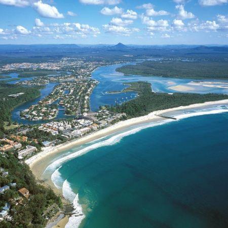
Sunshine Coast and Noosa Councils are partners in the project funded by the Australian Government to map the coast from Kings Beach at Caloundra to Noosa Main Beach.
How it works
It will use wind, wave and landform information to numerically model how the sand and sediment will travel along the coast over time.
In the short-term, the model could be used to predict erosion hot spots for upcoming storm events.
In the longer-term, it would show how a beach responds to sea-level rise and management actions like nature-based solutions, dredging and nourishment projects, seawalls or groynes and headland bypassing systems.
The modelling will also be used to inform future management actions and updates to important management plans such as Coastal Hazard Adaptation Strategies and Shoreline Erosion Management Plans.
Sunshine Coast Council Environment and Liveability Portfolio Councillor Peter Cox said our coastline was an important part of our lifestyle.
“Climate change means our environment is changing and this model gives us a clearer picture of what might happen in the future,” Cr Cox said.
“More information will help councils respond to that change in the right way to try and reduce any future impact on our environment and communities.
“It’s great to partner with Noosa to plan ahead to make sure we can all enjoy our beaches now and in the future.”
Noosa Council’s Director of Strategy and Environment Kim Rawlings said the joint project would provide critical data to inform important future decision-making.
“As we grow our understanding of the dynamics of our coastline, it puts us in a much stronger position to make decisions around coastal planning and our built environment into the future,” she said.
Minister for the Environment and the Great Barrier Reef, Minister for Science and Minister for Multicultural Affairs Leanne Linard said it was vital that coastal local authorities be given every support in their efforts to proactively monitor future movements and changes to their coastlines.
“This is particularly critical now, with local authorities needing accurate data and reliable forecasting so they can adequately plan for climate change impacts on their coastal communities,” she said.
“This is why we are pleased to support the Sunshine Coast and Noosa councils with the Sunshine Coast and Noosa Regional Coastal Process Model initiative.
“This has been funded through the Australian Government’s Coastal and Estuarine Risk Mitigation Program 2022-23, through which the Queensland Government received $8.4 million to fund 10 projects across the State, including 7 projects for coastal councils to address sea erosion and storm tide inundation threats.
“Adapting and building resilience to the changing climate is vital for Queensland’s prosperity. We will continue to work with local governments affected by climate change to identify potential issues for their communities and help Councils address them.
“For example, our QCoast2100 program will bring climate resilience by enabling local governments to better understand their areas and assets at risk and seek ways to mitigate these risks.
“I congratulate the Sunshine Coast and Noosa councils for their investment to manage and preserve the Sunshine Coast’s iconic beaches, foreshores, and communities.”