'Citizen scientists' to map coastline changes using smartphones
Residents and visitors can help play an important role documenting changes to Noosa’s coastline over time. And it can all be done with the press of a button.
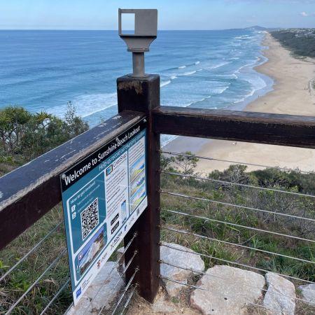
Residents can use their smartphones to help document changes to Noosa's coastline over time.
Council, in partnership with the University of the Sunshine Coast (UniSC), University of New South Wales and Queensland Parks & Wildlife Service, has installed a CoastSnap citizen science monitoring station in Noosa National Park overlooking Sunshine Beach.
The station houses a smartphone cradle where residents and visitors can place their phones to snap a photo of the coastline and upload it to a database using the CoastSnap app or a QR code.
“It’s a simple action we can all do as citizen scientists to help document changes to our dynamic coastline and assess the effects of climate change, coastal erosion and sea level rise over time,” Noosa Councillor Brian Stockwell said.
“The more photos we have of a particular site, the better our understanding becomes of how the shoreline position has changed and whether the beach is widening or compressing over time, and before and after storm events,” Cr Stockwell added.
The images of the coast are accompanied by date, time, and weather information.
Council’s Climate Change Adaptation Project Coordinator Shayan Barmand said the data collected will help inform coastal management and climate adaptation decision-making.
“UniSC is our main local coastal monitoring partner, so we’re pleased to work with their team, including Dr Javier Leon, plus Queensland Parks & Wildlife Service and UNSW, to translate insights from the citizen science data into management actions that build long-term resilience for our beautiful beaches and foreshores,” he said.
Dr Leon, a UniSC Senior Lecturer in Physical Geography, said community involvement would help his research team more closely follow changes in the Sunshine Beach foreshore over time.
“Currently, we can analyse historic changes from data collected at most monthly,” he said.
“This latest CoastSnap station is exciting because it will provide data much more frequently – whenever visitors choose to upload photos.
“We can convert the photos into meaningful information and feed this back into the community as evidence for future decision-making on beach management, from dune protection and sand nourishment to coastal planning.
“For example, closer monitoring may help us determine if sand has been completely lost to erosion or if it is only part of a cycle.”
University of New South Wales and the Water Research Laboratory created CoastSnap in 2017 and it has since become a global crowd-sourced photography platform in more than 13 countries.
The station at Sunshine Beach expands an existing network of stations across the Sunshine Coast.
The Sunshine Beach CoastSnap station is up and running now. For more information, visit the CoastSnap website.