Burgess Creek Catchment

The Burgess Creek Catchment is a small coastal creek catchment that discharges directly into the Coral Sea at Sunshine Beach. Covering roughly 545 hectares, it drains from the back of residential developments in Noosa Head, through bushland and community facilities near Eenie Creek Road, and then through a Council-managed Bushland Reserve and National Park. 


Burgess Creek mouth erosion

Burgess Creek mouth erosion

View maps of the Burgess Creek:

Natural areas

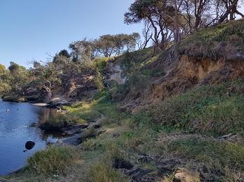
Nearly 300 hectares of the catchment is natural area, including the Girraween Nature Refuge, owned and managed by Council, and a section of Noosa National Park. Most of the natural area in the catchment is mapped as wetlands. The water from the surrounding landscape drains into it, and the wetlands soak it up like a big sponge. Water infiltrating the ground, particularly where the natural vegetation, leaf-litter and hydrology remains, drains much more slowly into creeks than water from developed areas. This means that water flows into creeks from natural areas last a lot longer than water flows from developed areas and stormwater. The prolonged release of water observed here is a sign of the wetlands holding onto water that contributes to the conditions that makes them wetlands, and only slowly releasing them.

  • While Burgess Creek itself is affected by treated water and stormwater discharge, it helps protect Noosa River, Laguna Bay and the Coral Sea, particularly inshore waters. The higher levels of infiltration, filtration and nutrient uptake afforded by the natural surfaces and native and weedy vegetation in the bed, banks and surrounds of Burgess Creek reduces the amount of water, sediment and nutrient entering the Coral Ocean and being swept up into Laguna Bay when compared to a piped outfall. This in turn helps improve inshore water quality and reduces algal blooms.

    The Shire's A- Healthy Land and Water Report Card rating in iNoosa River's lower reaches is due in part to it not receiving the lower quality water inputs from the densely populated coastal areas it might otherwise.

    Girraween Nature Refuge and the section of Noosa National Park included in the catchment have significant environmental values. There are several significant ecosystems with landscape scale environmental values, including a regional wildlife corridor, habitat value for at least 13 significant species and wetlands.

  • Burgess Creek Bushland Reserve is approximately 10.9 hectares of parcels of unallocated state land which includes water infrastructure, parks and gardens and unconstructed portions of the David Low Way road reserve. It is immediately west of the David Low Way, on the boundary between Sunrise Beach and Castaways Beach. 

    Most of the reserve is unallocated state land, with Noosa recently entering into a Deed of Agreement to manage weeds on unallocated State land with Queensland Department of Resources. This is in recognition of high levels of community interest and management activities under Council’s Community Bushland Care Program. 

    Despite past and ongoing impacts, some of them highly significant, Burgess Creek contributes significant site and landscape conservation biodiversity and environmental values. Values include waterway and land-based wildlife connectivity, essential habitat, significant species and connecting nearby national park to the coastal foreshore strip.

    It is highly valued by the local community, with enthusiastic Bushcare volunteers contributing to planning and rehabilitation activities in the reserve, supported by Council’s Natural Areas team.

  • The brown, tannin-stained water seen in many of Noosa’s coastal creeks is natural and identified by the Department of Environment and Science as characteristic of the coastal Noosa area. The freshwater wetland subtype is described as:

    Wallum/tannin-stained freshwaters: Tannin-stained, generally low gradient, small to mid-sized streams, many with sandy substrates and low pH, tea-coloured water draining through wallum vegetation.

    Many of the coastal creeks, including Burgess Creek, drain through what is currently or was recently wallum and paperbark wetlands and are caused by tannin from the native vegetation and naturally slightly acidic environment. The same dark brown water can be seen in the Noosa Everglades and other coastal freshwater wetlands with largely natural catchments and is not a sign of pollution or contamination.

  • Council is maintaining its program of public health water quality testing across the Shire, including for Burgess Creek, to understand the public health status and risks to recreational waters in Noosa.

    While periodic water quality sampling has generally shown bacterial levels to be within the guidelines for secondary recreational water use, as described by the National Health and Medical Research Council, results can be high from time to time. Swimming in Burgess Creek with head below water and drinking water from the creek is therefore not recommended.

  • Noosa Council’s integrated water quality monitoring program across Noosa Shire is assisting in better understanding changes in water quality from a range of sources around the catchment, including heavy rainfall events.

    Noosa Council’s Rivers & Coast branch undertake scheduled monitoring at sites in the Burgess Creek catchment to monitor water quality.

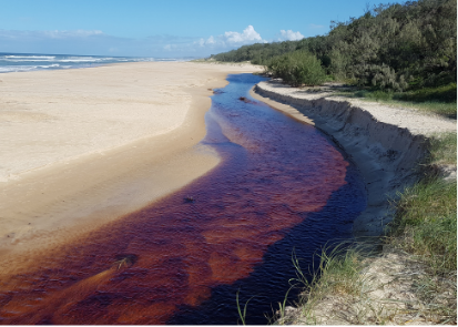
Erosion concerns near the mouth of Burgess Creek

Foot traffic erosion

Foot traffic erosion

There are two erosion concerns near the mouth of Burgess Creek.

The northern bank of the creek near the mouth, east of David Low Way is eroding due to a combination of uncontrolled foot traffic across the bank, and high peak waterflow during rain events.

Many beach visitors are also accessing the creek mouth and surrounding dunes which is contribution to erosion.

At the mobile mouth of the creek, up to 270 metres of the frontal dunes to the north of the creek mouth may be eroded during high flow events. This is not related to the erosion in the high foot traffic area.

Engineering programs for creek mouth management

Council is undertaking engineering design incorporating natural stabilization to manage the erosion that is occurring on the eastern beaches.

More broadly, detailed catchment analysis including treatment plans for stormwater run off, and environmental controls are needed.

Apart from Burgess Creek, Seaview and Castaways creeks require creek relief and there is a project underway to develop priority ratings that will facilitate a process of active monitoring and maintenance.

Land uses and catchment impacts

  • The Unitywater Noosa Sewage Treatment Plant discharges treated effluent into Burgess Creek near the Girraween Sports Complex on Eenie Creek Road, supporting urban residential development in the area.

    Urban stormwater from residential development in Noosa Heads, Castaways Beach and Sunrise Beach. The headwaters of Burgess Creek drain from and through low density urban residential development and an aged care facility in Noosa Heads. Minor sub-branches in the lower reaches drain from low density urban residential developments in Castaways Beach (from the south) and Sunrise Beach (from the north). Most of these urban properties are hardened, with roofs, concrete and other water-resistant surfaces preventing water infiltrating the soil where it falls. This means most of the water that falls on the properties is concentrated and quickly runs off the property and is further concentrated via gutters and stormwater systems.

    Storm water inputs from developed properties and roads are more concentrated, have more volume and are delivered more quickly than natural flows, which increase the volume and peak height of creeks after storms. This increased and concentrated flow can cause erosion and sedimentation, deepen and widen flowlines and cause landslips.

    Storm water also often carries nutrients, weed seeds and other pollutants into the creek.  Where storm water is discharged straight into natural areas it can cause erosion, sedimentation and weed infestations from the seeds and nutrients in the stormwater.

  • Noosa Heads Police Station, Queensland Ambulance Service and Noosa Heads Fire & Rescue are examples of these where the impacts are similar to those associated with residential development, although there may be high water flow events associated with operational or training activities.

    The Girraween Sports Complex does not irrigate with treated water from the sewage treatment plan, but does fertilise their field, and run-off is likely to include increased nutrients.

  • A significant amount of the normal flow level below the treatment plant is from the treatment plant. The normal flow level treated water into Burgess Creek has changed the creek and adjacent wetlands – the amount, duration and consistency of flow has increased, as has the area of permanently inundated land, which has changed the distribution of wetland and waterway species that can live in areas of high inundation and high levels of nutrients.

    Increased flows also occur during rain events due to increased stormwater discharge into the catchment and creek.

  • In April 2021 Unitywater commenced a consultation phase with Sunshine Coast councils including Noosa Council and the community to develop a long-term approach for total water cycle planning, known as Water Matters.

    Find out more about Unitywater’s Water Matters Plan.

  • Environmental Values (EVs) and Water Quality Objectives (WQOs) are established under the Environmental Protection (Water) Policy by the State Government in consultation with local communities.

    EVs set out the qualities that make natural waters suitable for supporting aquatic ecosystems and human uses such as drinking water, recreation, irrigation, and aquaculture. The EVs need to be protected from the effects of habitat alteration, waste releases, contaminated runoff and changed flows to ensure that aquatic ecosystems remain healthy and waterways are safe for community use.

    The WQOs are long-term goals for water quality management. They are technically-derived numbers, measures or narrative statements regarding particular indicators of water quality such as the physical, chemical, and biological indicators of water quality, pathogens, and measures of waterway condition e.g. erosion.

    In 2019 the Department of Environment and Science began reviewing its EVs and WQOs for the Noosa River.

    A full review occurs at least every 10 years, or as additional information becomes available, while minor reviews can be made at any time.

    Maps relating to the EVs and WQOs have been updated to reflect an expansion in areas of High Ecological Value areas outside of conservation areas where water quality is the same.

    Council provided a submission as part of the consultation and advocated for a new sub zone Primary Recreation EV to be included at the mouth of Burgess Creek due to high resident use and dog interactions. The Department of Environment and Science subsequently shifted the EV zone slightly inland, while the beach itself was already within a zone that includes Primary Recreation.

    The revised EVs and WQOs are expected to be finalised by July 2022, and the maps are available online at Queensland Globe or can be downloaded from Q Spatial.

  • Council’s Rivers and Coasts team is currently developing an ecological restoration plan for Burgess Creek Bushland Reserve in collaboration with the Burgess Creek Bushcare group, Bushland Care program, Council’s Natural Areas team and Unitywater. This plan will allow for investigation of the values of Burgess Creek Bushland Reserve and issues surrounding its ongoing management. It will guide the management of Burgess Creek Bushland Reserve for the next 5 years. 

    Development of Council’s Eastern Beaches Foreshore Management Plan has identified the need for a Catchment Management Plan for Burgess Creek. This plan will allow for investigation of the values of Burgess Creek Catchment, and of sources of water, nutrients, and other chemicals in the catchment.

  • Council’s Infrastructure, Environment Services and Climate Change branches are working with UniSC on a monitoring project at Burgess Creek. The proposed research aim is to investigate the reasons behind Burgess Creek’s channel migration at event time scales (decades). The objectives of the study are to: 1) monitor water quality, 2) monitor the 2D and 3D morphological change of the creek; 3) relate the observed changes in water quality and morphology to boundary conditions (e.g., waves, the creek’s water surface level, rainfall, and discharge), and 4) develop an empirical model to predict triggers forcing changes in water quality and the creek’s morphology.

    The creek’s planform change, channel depth and beach/dune volumetric changes will be surveyed using drone photogrammetry and RTK GNSS profiles on a ~monthly and/or event-driven basis (e.g., before/after significant swell or rainfall events). Nearshore hydrodynamics (waves and currents) will be modelled using a calibrated SWAN model. An XBeach model will be used to model beach/dune volumetric changes and tested using observed data.

    The creek’s water surface level will be monitored using a pressure sensor at the mouth (west side of the bridge) based on significant events (e.g., during significant swell >3m Hsig and/or >10mm rainfall events). The creek’s flow velocity will be continuously monitored (every 30 seconds) using a water flow meter at a fixed site (west side of bridge). Flow data will be uploaded daily and will be accessible to Noosa Council via UniSC’s online data account. The channel’s morphology will be surveyed to estimate the creek’s discharge based on monitored flow.

    Water quality samples will be collected at the same site west of the bridge, and the outflow site (Wallum Lane – Rotary Way, Noosa STP) monthly and tested for concentrations of e.coli, enterococci, total nitrogen, total phosphorus and total suspended solids.

    A stage/discharge relationship or rating curve will be developed for the creek, and data will be collated and analysed to develop an empirical model that will explain the main triggers and predict thresholds that force the creek’s morphological and water quality changes.

    The practical and easy to use decision support tool based on the empirical model developed from this project will benefit the management of Burgess Creek by determining the thresholds best suited for actions. For example, the tool could be used to determine when is best/necessary to open the creek’s mouth to mitigate dune erosion or when the creek’s water quality could be expected to be a health hazard.

    Abbreviations

    GNSS:    Global Navigation Satellite System
    Hsig:      Significant wave height (m)
    RTK:       Real-Time Kinematic
    STP:       Sewage Treatment Plant
    SWAN:  Simulating WAves Nearshore
    UniSC:   University of the Sunshine Coast