Cooroora Trail

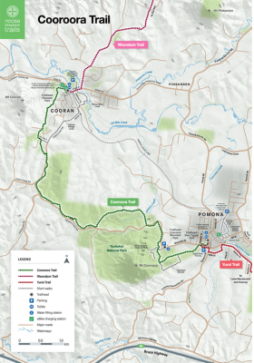
This shady trail winds through eucalypt forest and grazing land past the peaks of Mt Cooran and Mt Cooroora. Stop and have a break on the banks of Wirruna Drive Bushland Reserve Lake or one of several bench seats along the trail with views of Mt Cooroora. The trail works well as a two-way journey with lunch options at both Cooran and Pomona and a railway line servicing the towns if you run out of steam. Trains are infrequent so best to plan ahead.
Distance | 10km one way
Surface | Natural
Suitable for | No bushwalking experience required, suitable for mountain bikers with basic skills, horse riders and horses with moderate skills and fitness recommended.
Look around ... life abounds
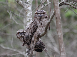
Tawny Frogmouth
You are now standing on Kabi Kabi Country and traversing the Cooroora Trail. The majority (70%) of this trail meanders through Tuchekoi National Park, where an abundance of life and land to discover awaits you.
Here, watercourses are woven through the landscape, forming a network within the Mary River catchment. The catchment supports aquatic and land-dwelling creatures alike by providing clean drinking water and fishery resources, and creating space for recreation, learning and inspiration.
Several endemic and endangered species call this catchment home, including the Mary River cod (Maccullochella mariensis) and
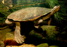
Gs elusor macrurus
the Mary River turtle (Elusor macrurus), which can stay underwater for days at a time by breathing through its rear end! The Mary River flows to the Great Sandy Strait, an internationally significant RAMSAR wetland, and passes through pristine beaches before being engulfed by the Pacific Ocean and stretches of the southern Great Barrier Reef.
Tuchekoi National Park encompasses diverse vegetation types, from open eucalypt forest and woodlands to rainforest gullies. In the open eucalypt forests and woodlands, light filters through gaps in the canopy and if you are lucky, you may see a tawny frogmouth (Podargus strigoides) or even a koala (Phascolarctos cinereus) –
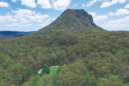
View from the trail
keep an eye out in the forks of trees, particularly in eucalypts such as blackbutt (Eucalyptus pilularis) and tallowwood (Eucalyptus microcorys)! The blackbutt gets its name from the rough bark at the tree base which can be charred black from past bushfires.
The forests here are some of the most complex formations in the Noosa region. Little light penetrates through the dense canopy, yet life persists at all levels in a tangle of trees, vines, epiphytes, forbs, sedges, shrubs and grasses.
Tuchekoi National Park was founded on complex geological processes starting around 280 million years ago! These processes included volcanic chains, collisions of continental and oceanic plates and layering of sediments. Imagine what the landscape would have looked like back then! Look to the southern horizon and you will find the mighty Mt Cooroora. Formed over 20 million years ago by the cooling and hardening of lava in a volcanic vent, it is the highest point of Tuchekoi National Park, towering at an impressive 439 metres.
Follow this trail to discover more of what this wondrous region has to offer.